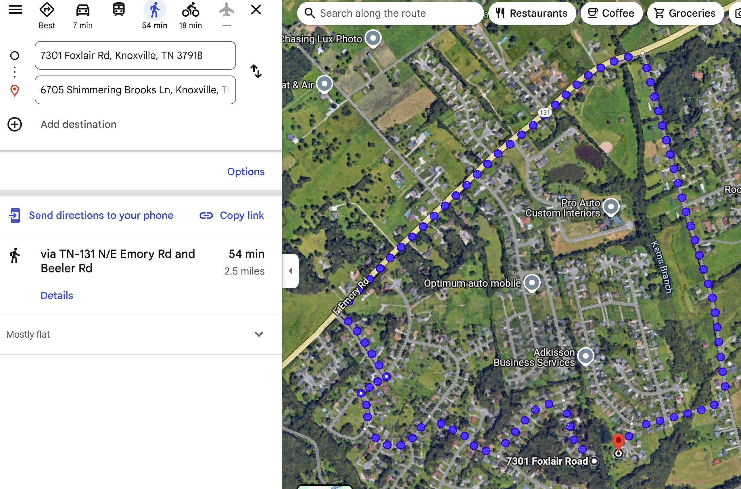
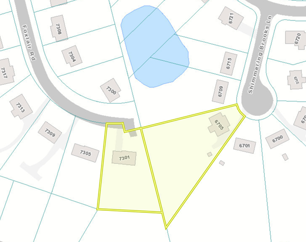
top of page

What

What do I need to know?

What does the city office of neighborhoods do?


What does the county office of constituent services do?

The goal of the County Mayor’s Office of Constituent Services is to give citizens ready access to their government and working to resolve community concerns. We are proud to be an informational and educational resource regarding county services and local government. We provide direct, efficient access to county departments and promote two-way communication with constituents concerning their community needs.

​

Our team is devoted to making sure Knox County residents feel supported by and connected to their local community and County government.

​

One way our office can connect to your community is through our Neighborhood and Civic Registration program. Our office will send updates regarding road closures, public meeting notifications for County Commission, Knoxville-Knox County Planning and provide updates on other county projects within your community.

​

Mayor Jacobs is committed to creating opportunities for everyone to thrive in an engaged and vibrant community—showing the world what we already know, Knox County is the best place to live, work and raise a family. 

constituent.services@knoxcounty.org


What does the department of engineering do and what role do they play in the process?

​

What is Municipal Engineering?

​

Municipal engineering is a facet of the broader category of civil engineering and focuses on designing, constructing, and maintaining various types of infrastructure, facilities, and utility systems. These functions are handled by Municipal Engineers who work for Townships, Boroughs, Cities, and Authorities. In addition to infrastructures, Municipal Engineering includes responsibilities focused on environmental issues and tasks that contribute to the quality of life for municipal residents.

​

What are the Key Roles and Responsibilities of a Municipal Engineer?


Municipal Engineers have an extensive range of roles and duties that they may need to fill throughout their careers. Providing consulting services that include, but not limited to:

  • Review of Land Development Plans for conformance to a Municipality’s Codes and Ordinances.

  • Evaluating and improving existing stormwater and flooding issues

  • Pursuing Federal, State, and Local funding for projects

  • Developing and managing budgets for engineering services

  • Conducting and reporting feasibility studies, economic analyses, and traffic studies

  • Overseeing master plans and the details of streets and flood control

  • Maintaining official Municipal roadway, zoning, and utility mapping

  • Overseeing the design and planning of Municipal systems

  • Manage the construction of Municipal infrastructure projects

  • Observe the construction of site improvements for Land Development Projects


What Are the Most Common Services Municipal Engineers Provide?


Water and Wastewater Services

Many Municipal Engineers spend most of their time working with water and wastewater facilities and services. This includes the water and sewer pipeline systems that serve surrounding homes, schools, and businesses throughout our communities. Municipal Engineers are involved at every step of the way, from conveyance to pumping stations to storage tanks and treatment plants. They are also often called upon to consult on plans and technical specifications for equipment, materials, and construction projects.


Stormwater and Drainage

In helping to protect communities, Municipal Engineers provide support in stormwater management by proposing, designing, and observing the construction of these viable solutions. Often times, they are working to correct existing stormwater issues with drainage facilities that are found to be inadequate or non-existent. A common issue is excessive rainfall levels, rendering drainage systems, or the use of stormwater recovery methods a must-have need to ensure best management practices are put in place.


Land Development

Municipal Engineers play a crucial role with subdivision and land development reviews, as they are responsible for reviewing designs to make sure they are in accordance with regulations such as the Subdivision and Land Development Ordinance (SALDO) and Stormwater Management ordinance (SWMO). He/she also determines that any design’s feasibility along with the assessment of land is deemed able to support the full development plan.


Traffic and Transportation

Our roadways and transportation systems demand constant attention from Municipal Engineers. Focusing on things like reviewing and preparing traffic studies, parking optimization studies, regional and sub-regional planning studies, signal planning and specification, and pedestrian transportation enhancement, municipal engineers work collaboratively with elected and appointed officials and staff, municipal staff, other consultants, residents, applicants, and permitting agencies to help see projects through from concept to the final design.


Structural Engineering Services

Municipal Engineers play a major role in designing, constructing, and maintaining structures such as culverts and bridges, with input in various aspects of each project. They consult with architects, designers, and other building contractors on structural layouts, loads from snow, or seismic activity and help decide what structural systems to use. They work with various building systems and materials, including steel, concrete, masonry, and wood, and select structural support elements like beams and columns.


Construction Administration

Construction Administration services are a comprehensive blend of planning and observation solutions and provide various types of documentation to federal, state, municipal, and community relations organizations. Construction managers are involved in the day to day building process for highways, bridges, utilities, and other municipal facilities. Municipal Engineers who specialize in construction management are likely certified by several industry regulators, including NICET (highway construction), ACI (concrete testing), and NECEPT (bituminous concrete pavement).


What role does the planning commission staff play in the process?  

The Planning Services Division studies community growth patterns and prepares plans that guide agency policy. Community facilities, neighborhood planning, and commercial corridors are part of the work of this division.


In addition, Planning Services staff partners with the city and county staff to administer zoning ordinances, county zoning resolution, and subdivision regulations. Applications for rezoning, use on review, subdivision and sector plan amendments are reviewed monthly and a recommendation regarding each application is prepared. Amendments to the One Year Plan are reviewed quarterly with recommendations made in April, July, October, and January. The department is responsible for published notices, posting of notices on property, and community meetings concerning pending applications. Staff assigns addresses for city and county streets and land parcels.


Does the Planning Services Division have useful resources?

Library, Public Information, Demographic and Economic Data, Development Reports, Graphic Design, Website, Computerized Mapping (GIS)


The Planning Library is a source and clearinghouse for all published information and reports. Citizens who need or desire information regarding population, housing, employment, transportation, and much more may avail themselves of the services of the library.


This division provides the website, computer mapping, graphic design, public relations, and reference services to the agency. The Geographic Information System (GIS), a computerized database and mapping system operates from these divisions. Planning graphic design and publications are also part of the work. Keeping current statistics, reports, and maps is an integral activity of these divisions which closely coordinates with programs of citizen information and participation.


​Who conducts transportation planning?

Transportation, Traffic Engineering, Title VI, Traffic Control Studies, Intermodal, Public Involvement


The Transportation Planning Division acts as staff to the Knoxville Regional Transportation Planning Organization (TPO), a transportation planning board serving the urbanized area of Knox, Blount, Loudon, and Sevier counties. TPO is responsible for developing a twenty-year long range plan and a transportation improvement program in cooperation with the state and affected transit operators and the public.


​Why can staff recommendations be overturned by Planning Commission?

The Planning Commission votes on a number of items at its regular meeting. Some recommendations, such as Rezonings, Sector Plan changes and Ordinances require further action by Knox County Commission or Knoxville City Council. In other cases, such as Use on Review and Concept Plans, the decision by Planning Commission is final if denied, unless appealed to court.


What is expected of them?


If they are experts, why can their recommendation be overturned?


What is a defensible argument for approving a zoning and or sector plan amendment request? 


What criteria for approval is used?  


What is the difference between land use classifications and zonings?


Do the property taxes and fees collected by the city/county cover the impact and or infrastructure improvement costs to my community?


Is the applicant required to pay for the impact of their development to my community?


An impact fee is a fee that is imposed by a local government within the United States on a new or proposed development project to pay for all or a portion of the costs of providing public services to the new development.  Knox County does not have an impact fee.


If the city or county needs my land for infrastructure improvements, will I be compensated?

Eminent Domain


The power to take private property for public use by a state, municipality, or private person or corporation authorized to exercise functions of public character, following the payment of just compensation to the owner of that property.

Federal, state, and local governments may take private property through their power of eminent domain or may regulate it by exercising their Police Power. The Fifth Amendment to the U.S. Constitution requires the government to provide just compensation to the owner of the private property to be taken. A variety of property rights are subject to eminent domain, such as air, water, and land rights. The government takes private property through condemnation proceedings. Throughout these proceedings, the property owner has the right of due process.

https://legal-dictionary.thefreedictionary.com/Imminent+Domain


What is LDR? Can different areas of the city / county have different determinations?


Are there plans for growth in place and are they followed?  Why are they advisory?


What is advisory and what is regulatory?


  •     Growth Policy Plan is regulatory

  •     General Plan is advisory

  •     Sector Plans are advisory

  •     Zoning Ordinances are regulatory

  •     Subdivision Regulations are regulatory

  •     Building codes and permits are regulatory

  •     Student yield is used for advisory purposes


What is the cost to update a sector plan?

Sector plans provide recommendations for land use, community facilities, and transportation systems across 12 geographic divisions of Knox County.

​

They focus on applying goals from the Knoxville-Knox County General Plan 2033 to guide land use and development over a 15-year period. And for the near term, five-year capital improvements and implementation programs also are provided in each sector plan.


Are the regulatory oversights state or local?  Are they enforced?


If zoning and or a sector plan amendment is approved, does it stop there?


Can the planning commission overrule the staff recommendation?


Can county commission overrule planning commission’s decision?


Does the district councilperson or commissioner’s position on a zoning and or sector plan amendment hold weight at that level?


What do decision makers look for?


What is the cost for one mile of road?


What is the cost for one mile of sidewalks?


What is a bond?  How do they work?

What are municipal bonds? Municipal bonds (or “munis” for short) are debt securities issued by states, cities, counties and other governmental entities to fund day-to-day obligations and to finance capital projects such as building schools, highways or sewer systems.


State and local governments issue bonds to pay for large, expensive, and long-lived capital projects, such as roads, bridges, airports, schools, hospitals, water treatment facilities, power plants, courthouses, and other public buildings. Although states and localities can and sometimes do pay for capital investments with current revenues, borrowing allows them to spread the costs across multiple generations. Future project users bear some of the cost through higher taxes or tolls, fares, and other charges that help service the debts.

​

States and localities issue short-term debt or notes to help smooth uneven cash flows (e.g., when tax revenues arrive in April but expenditures occur throughout the year). They also issue debt on behalf of private entities (e.g., to build projects with public benefit or for so-called public-private partnerships).


What is Tax Increment Financing?  PILOT?

​

    https://knoxdevelopment.org/business-assistance/tax-increment-financing/

​

How much infrastructure improvement cost is the applicant responsible for?  The city? The county?


How are infrastructure costs funded in the city? County?


Should we hire an attorney?

This decision is dependent upon many variables. In most cases, citizen and neighborhood representation along with good preparation is adequate. However, KCPA maintains a list of neighborhood-friendly land use attorneys.


What is slope?

​

What is the Slope Analysis formula?


Who is watching the market?  


Do plans impact the market?


What are property rights?

Property rights define the theoretical and legal ownership of resources and how they can be used. These resources can be both tangible or intangible and can be owned by individuals, businesses, and governments.


What property rights are considered for zonings and plan amendments?

Property ownership comes with many rights; however, these rights are often superseded by local zoning ordinances. Zoning regulations impose restrictions on how a particular property can be used and establish requirements such as building heights and setbacks. Some property owners view these ordinances as an infringement upon their constitutional right to personal property. On the other hand, zoning advocates maintain that zoning ensures land is developed in a manner that protects the rights of all members of a community.

​

Private Property Rights

Property rights consist of various rights that can be held by different entities. These rights can be compared to a bundle of sticks, as they can be held together by one person or distributed to different parties. They can also be surrendered by means of a deed restriction. The bundle of rights includes the right to sell the property, to build on the property, to lease the property, to control access to the property, subdivide the property, grant easements on the property and to mine or farm the property. Property rights are protected by the Fifth and Fourteenth Amendments of the U.S. Constitution.

​

Zoning

Zoning ordinances establish whether land shall be used for residential, commercial, agricultural or industrial uses. The ordinances also dictate the manner in which the land is developed by restricting the density, building heights, parking, setbacks and other attributes related to development. Zoning seeks to either limit or encourage growth within the community depending on the aim of local government. Before a property owner is able to build on his property, he must meet all of the zoning conditions in order to receive a building permit, unless an exception called a variance is made.

​

Appeals

Zoning decisions are not always final. If your local planning commission rules that your proposed plans do not conform to the zoning, you can file a claim with the board of zoning appeals where you can argue your case. You can also apply for a variance, which allows for an exception to an existing zoning law. Another option is to obtain a conditional use permit, which permits you to use the land as you propose as long as you meet special conditions. If local zoning officials continue to rule against you, you can always challenge them in court and hope a judge or jury sees things your way. This is an expensive and time-consuming route to take, but the courts are often the final arbiter as to whether zoning or private owner's rights prevail.

​

History

Zoning in the United States began in earnest in New York City with the passage of the 1916 zoning resolution. The resolution established height and setback requirements for buildings in the city. It was a direct response to the construction of the Equity Building, which cast a seven-acre shadow over neighboring property that lowered property values. As zoning ordinances spread across the United States, they were challenged by those who felt that the ordinances were a violation of their individual rights to do what they wanted with their own property. Eventually the issue was addressed by the Supreme Court in the 1926 decision of Village of Euclid v. Ambler Realty Co. The court ruled that zoning regulations were a legitimate use of government authority.


Does zoning affect property value?

Because of the zoning, the value of the property is diminished as the number of buyers that would have a use for the building has now been greatly reduced which, based on supply and demand , would lessen the value of the building. Another example might be the density requirement of zoning.

​

What is highest and best use of land?

A property must be appraised in terms of its highest and best use. The definition of highest and best use is as follows: The reasonable, probable and legal use of vacant land or an improved property, which is physically possible, appropriately supported, financially feasible, and that results in the highest value.

​

What is the Student Yield Formula?


The local planning commission calculate an average student yield for each of three types of housing unit construction: single-family detached, single-family attached, and multi-dwelling (apartment). Yield, measured as number of new school-age children per new housing unit, is calculated from actual student addresses (provided by Knox County Schools) matched to new housing unit (building permit) addresses. Additionally, we calculate average yields for different geographic areas of our county, as we've observed over the years that different areas generate slightly different rates of yield.


So using actual local data, we know the number of new students that move into each new housing unit built each year in different areas of the county. 


We use a few years of enrollment and building permit data to calculate our yield averages. And those averages are updated every couple of years and provided to our planners for consideration in their case reviews. 


Currently, the student yield numbers used by our planners are summarized as follows:


Multi-dwelling:  

0.0903 students per unit - county-wide


Single-family attached:  

0.0219 students per unit - most city sectors

0.0274 students per unit - east, northeast, south county

0.0723 students per unit - north, northwest, southwest county


Single-family detached:

0.3321 students per unit - east, northeast, south county

0.3565 students per unit - most city sectors

0.4101 students per unit - north, northwest, southwest county

​

Meeting Schedules - Application Deadlines - Fee Schedules

    https://knoxmpc.org/applications

​

​

​

What should I look for when reviewing a Planning Agenda land use item?


KCPA has created a Check List that will help guide you when reviewing agenda items.


Preliminary Agenda: The preliminary agenda contains a list of cases scheduled to be heard along with a brief description of the property, location, and requested action. The preliminary agenda is available 12-14 days prior to the Agenda Review Meeting held the second Tuesday 11:30am of each month.  Anyone can register to receive the monthly preliminary agenda via email and submit comments.  There is no public forum at the preliminary agenda.  


Agenda: The final agenda is the set list of cases to be heard along with staff recommendations and public comments.  The agenda is available 6 days prior to the scheduled meeting on the second Thursday 2:30pm of each month. Anyone can register to receive the monthly agenda via email and submit comments or request to speak.  Public forum consists of 5 minutes total is allowed for the applicant and 5 minutes total allowed for the citizen(s) for each agenda item.  More time may be granted by commissioners.


What should my email to Planning Commission include?


What should my email to County Commission or City Council include?


What is zoning?


Zoning allows local governments to regulate which areas under their jurisdiction may have real estate or land used for particular purposes. Examples of zoning classifications include residential, commercial, agricultural, industrial, or hotel/hospitality, among other more specific designations.


The City of Knoxville and Knox County have adopted zoning regulations as part of their code of ordinances.These ordinances detail a variety of zoning districts, uses permitted and certain specifications for building and other site improvements .https://knoxmpc.org/zoning/regulations

To locate zoning information regarding a specific piece of property, you can use the interactive features on KGIS Maps https://www.kgis.org/KGISMaps/Map.htm

You may also search the Knoxville Knox County Planning Commission website https://knoxmpc.org/


How is zoning determined?


What is a land use classification?

Land-use classification schemes typically address both land use and land cover. A major land-use classification system developed by the United States Geological Survey (USGS) has multiple levels of classification. The categories within these levels are arranged in a nested hierarchy. The most general or aggregated classification (level I) includes broad land-use categories, such as ‘agriculture’ or ‘urban and built-up’ land (Table 1). This level of classification is commonly used for regional and other large-scale applications. Within each level I class are a number of more detailed (level II) land-use and land-cover classes. For example, the ‘urban and built-up’ class includes ‘residential,’ ‘commercial,’ and ‘industrial’ subclasses. Within each of the level II classes, even more detailed classes (levels III and IV) can be defined and mapped. The classes within each level are mutually exclusive and exhaustive. That is, each location within the mapped area can be classified into one and only one class within each level. Together these four levels of classification comprise a hierarchical system for describing, monitoring, and predicting land-use and land-cover change. This standardized, multilevel classification system allows spatially explicit comparisons of land-use inventories conducted over time.


To locate land use classifications regarding a specific property, you can use the interactive features on KGIS Maps   https://www.kgis.org/KGISMaps/Map.htm

or visit  https://knoxmpc.org/plans/land-use


How is land use classification determined?

Land use classifications for Knoxville, Knox County, and the Town of Farragut are defined in the state mandated Growth Policy Plan and formulated by the Growth Policy Plan Coordinating Committee. Land use is categorized into 3 land use classifications: Rural, Planned Growth, and Urban Growth.


Tennessee Public Chapter 1101 provided that counties and their associated municipalities were to develop countywide growth plans. These plans were to be developed and recommended by coordinating committees and submitted to the county commissions and the governing bodies of the municipalities within the county.


​

What is the Knoxville Knox County Farragut Growth Policy Plan?


Public Chapter 1101 provided that counties and their associated municipalities were to develop countywide growth plans. These plans were to be developed and recommended by coordinating committees and submitted to the county commissions and the governing bodies of the municipalities within the county.  Counties and municipalities could either reject or ratify those plans.  Ratified plans were submitted to the Local Government Planning Advisory Committee (LGPAC) for approval.  County and municipal governments could declare an impasse if agreement could not be reached and have plan conflicts resolved by the Administration Procedures Division of the Secretary of State's Office.  Eleven county growth plan disputes were resolved by the Administrative Law Judge (ALJ) panels, and in one case the growth plan was developed by an ALJ panel with the assistance of a consultant hired by the office.

​

By 2003, all 92 counties required to develop growth plans had done so, and all plans were subsequently approved by LGPAC—Davidson, Moore, and Trousdale continue to be exempt from PC 1101 because each has a consolidated metropolitan government.  Thirty counties have amended their initial plans, some multiple times.  For example, Wilson County amended its growth plan in response to a growth boundary expansion requested by one of its cities and a retraction requested by another.  Hamblen County amended its growth plan four times in the mid-2000s to allow Morristown to annex territory that was initially outside of its very narrowly drawn UGB.

​

The growth plans established Urban Growth Boundaries (UGBs) for municipalities, Planned Growth Areas (PGAs), and Rural Areas (RAs) for counties.  PC 1101 provided a sound basis for long-range planning for future growth and required that certain planning studies and land use and population projections be completed before proposing a UGB, PGA, or RA.  These requirements were an effort to link growth plans to existing general municipal and regional planning under Title 13.  For example, a UGB identifies the extent of a municipality’s regional planning area that can be approved under Title 13 for long-range planning and subdivision regulation enforcement.  A county PGA identifies the potential locations for new incorporated municipalities and shows where a county may direct urban type development as well as places for the generation of sales tax revenues.   A county RA identifies areas that may be reserved for low intensity development, agricultural land preservation, and environmental protection.

​

During the years leading up to the passage of PC 1101, there were many battles over annexation and incorporation of new municipalities.  PC 1101 was an attempt to settle those differences, though it was also an effort to encourage growth planning statewide.  Annexation remains a contentious issue for growth planning despite the passage of PC 1101 and subsequent legislation. 

​

Public Chapter 707, Acts of 2014, made significant changes to Tennessee’s annexation laws, eliminating annexation by ordinance without property owners’ consent.  As a result, municipalities can annex new areas by resolution only with the written consent of the proposed area’s property owner(s) or by referendum of the voters living in the area proposed for annexation.  Even for areas located within a municipality’s urban growth boundary as approved under its county growth plan, non-consensual annexation is now prohibited.  In 2017, the General Assembly passed another amendment to the annexation statutes.  Public Chapter 399 allows municipalities to annex territory that is not contiguous to the existing municipal boundary but is within the urban growth boundary if specified requirements are met.

The new restriction on annexation initially raised questions about the utility of urban growth boundaries, but UGBs still have value and purpose.  In particular, one municipality may not annex areas inside another municipality’s UGB.

https://www.tn.gov/tacir/annexation/redirect---annexation-in-tennessee/comprehensive-growth-policies--public-chapter-1101-.html


    The purpose stated by the General Assembly for the Act is to

  • eliminate annexation or incorporation out of fear,

  • establish incentives to annex or incorporate where appropriate,

  • more closely match the timing of development and the provision of public services,

  • stabilize each county’s education funding base and establishes an incentive for each county legislative body to be more interested in education matters, and

  • minimize urban sprawl.


What is the difference between land use classification and zoning?

Land use, as the name suggests, is associated with planning, control, and rights of property. Zoning, on the other hand, is the allocation of land in a municipality by dividing them into different zones. The purpose of zoning is to protect and conserve the value of land use.


What is a permitted use?

A permitted use is a use that is allowed as long as the landowner meets all of the other requirements of the particular zoning category. Permitted uses allow for the use that is intended by the designation. For example, a certain business designation will allow restaurants, and another will allow gas stations.https://knoxmpc.org/plans/land-use


    Permitted uses vary among the city, county, and the town of Farragut.


Knoxville permitted uses: https://library.municode.com/tn/knoxville/codes/code_of_ordinances?nodeId=APXBZOCO_ART5COOFDI


Knox County permitted uses:

https://library.municode.com/tn/knox_county/codes/code_of_ordinances


Town of Farragut permitted uses:

https://townoffarragut.org/141/Planning-Land-Use


What is a Sector Plan?

A Sector Plan is a long-range plan for a specific geographic area of at least 15,000 acres in one or more local governmental jurisdictions. Local governments—or combinations of local governments—may adopt Sector Plans into their Comprehensive Plans.  A Sector Plan provides policy and regulatory guidance for development to ensure outcomes that are more predictable for the community and affected stakeholders, and supportive of the community's goals for the area.  Sector Plans are not codified and are considered advisory and can be amended at the request of an Applicant at monthly planning commission meetings.


Sector Plans are generally updated every 10-15 years dependent on the needs of a specific defined sector.  Planning experts, official departments, elected officials, and citizens all participate in scheduled public forums as part of the Sector Plan review process.


How are Sector Plans defined in Knoxville Knox County?

A sector is a geographical portion of Knox County defined for planning purposes. The Knoxville and Knox County area is divided into twelve sectors. A sector is not defined by the City Limits, so it can contain both City and County areas.

The Planning staff prepares a background report about the sector containing basic planning information about environmental resources, land use, population, transportation, community facilities, and utilities. With public input, the Planning staff drafts a conceptual 15-Year Plan that includes goals, policies and proposals to guide the sector's growth. The focus of the Plan is physical development; consequently, land use, transportation and community facilities are its key elements.

​

The adopted plan will be used on a month to month basis by the Planning Commission as the guide to zoning and subdivision decisions. A five-year improvement program will also be prepared, outlining projects to improve roads, parks, schools, and other facilities.

​

In 2007, Planning developed a standard land use classification table to use in all 12 sectors. The table includes descriptions, location criteria, and recommended zoning for each proposed land use classification.

​

The districts described at the link below are used by the Planning Commission, City Council and County Commission for decision making with regard to development and land use (including rezonings and plan amendments)

The completed Sector Plan is presented to the Planning Commission in final draft form. After approval by the Planning Commission, the Sector Plan is presented to City Council and County Commission for adoption.

​

Questions about sector plans can be directed to Planning Services staff, 215-2500

https://knoxmpc.org/plans/sector-plans/about

https://knoxmpc.org/plans/sector-plans


How can I participate in a Sector Plan?

Public participation is necessary for any planning process, but it is especially important for sector plans, because Planning staff makes decisions based on these plans every month. Citizens, business owners, employers and employees in the sector should participate. Planning reaches out to the public in multiple ways in preparing a plan. It is important that all citizens, who want to express their concerns or views in identifying issues and in creating and reviewing the proposed plan, have means to do so. The participation methods may include:

  • surveys, including both hard copy and on-line surveys

  • workshops with small group discussions

  • community association meetings

  • public meetings in the community

  • Planning Commission, City Council and County Commission public hearings

Press releases about the Sector Plan and the public meetings are sent to local media throughout the process. Mailings and e-mailings to community and business association leaders, and information is posted on the Planning web site: www.knoxplanning.org.

https://knoxmpc.org/plans/sector-plans/about

​

What is a One Year Plan?

​

What is density?

Density is a number of units in a given land area (project area, subdivision, parcel). Density is defined by how many housing units are in a development designated for housing, dwelling units per acre (du/acre). In mixed use projects, density is the number of housing units divided by the land area of the mixed- use development (that includes area used for non-residential uses such as office or retail space)


All density measures are calculated using the same basic ratio formula: the number of dwellings divided by the area of land they occupy. It is the land uses that are included in the land area which determine the type of density being described.


To calculate the net units per acre, divide the number of square feet in the net acres by the minimum number of square feet required for each lot by the applicable zoning district.


Applicable densities may be found in the municipality’s land use classifications in the land use classification description.

https://knoxmpc.org/plans/land-use#:~:text=Such%20land%20uses%20are%20primarily,units%20per%20acre%20(county).


Does the density apply to the total acreage?  Or useable acreage?  How is the useable acreage determined and by whom?


Which factors affect the land use pattern?

The land use pattern is determined by certain physical factors of the area such as topography, climate and soil types. The availability of geographical area determines its uses.


What does “highest and best use” of land mean and who does it apply to?


The reasonable, probable and legal use of vacant land or an improved property, which is physically possible, appropriately supported, financially feasible, and that results in the highest value. It is important because the highest and best use determines the most profitable use of the site, whether the subject is vacant land or an improved property on the site. The highest and best use usually requires less analysis when appraising an existing property rather than a proposed property.

​

What are blue line streams and are they protected?

A blue-line stream is a body of concentrated flowing water in a natural low are or natural channel on the land surface and may be any creek, stream or other flowing water feature, perennial or ephemeral, indicated on USGS quadrangle maps, with the exception of man-made watercourses.


Blue line streams are addressed under Stormwater in a municipality’s ordinances.


Knox County: https://www.knoxcounty.org/stormwater/manual/Volume%201/Appendices/A/knoxco_swmm_v1_app_a1.pdf


Knoxville City: https://library.municode.com/tn/knoxville/codes/code_of_ordinances?nodeId=PTIICOOR_CH22.5ST


​What should I look for when reviewing the request(s)?

KCPA has developed a Check List for reviewing land use and planning requests.


​What are the steps in the rezoning process?


The official rezoning process is detailed by the Knoxville Knox County Planning Commission and can be found here:  


What you need to understand is that from the time that you receive a public notification, either by mail or signage, the process happens quickly and you will need to act accordingly.  The Applicant has had months, maybe years, to prepare for their request.  Citizens have weeks to prepare their response, so time is critically important.


As a citizen, here are some steps to guide you:

  1. Review the application using the KCPA Check List. Answer as many questions possible from the information provided on the Knoxville Knox County Planning Commission website case file and or history.

  2. Reach out to the assigned Planning Staff member listed on the application request. Use the KCPA Check List to guide your conversation.

  3. Reach out to the Applicant.  Contact information is provided on the request. Ask the Applicant questions that enable you to complete the KCPA Check List.  Ask the Applicant to meet with members of your community.

  4. Connect with neighbors and members of your community impacted by the request.

    1. Determine the facts and the basis for support or opposition.

    2. Ask neighbors and community members to contact Planning Commission using the online platform.

    3. Appoint a spokesperson and sign up to speak.

  5. Email Planning Commission - participation and number of emails received makes a difference in how the Planning Commission addresses an agenda item.  Citizen engagement is critical. The online platform is the preferred method of communication with Planning Commission.

  6. Make plans to attend or view the Planning Commission Review Meeting - most discussion among Commissioners takes place at the review meeting.  The review meeting provides helpful information for crafting your message and formulating your basis for support or opposition.

  7. Make plans to attend the Planning Commission Meeting- citizen participation is critical and does make a difference.

  8. Speak Up - because public comment is limited to 5 total minutes, it is important to appoint a spokesperson to represent the community and present factual information for support or opposition of a request.

  9. REPEAT - zoning and sector plan decisions proceed to County Commission or City Council and usually occur at the next monthly meeting.  This means that all steps must be repeated but at the County Commission or City Council level.

  10. Appeals go to the Board of Zoning Appeals

​

What are the steps in the sector plan amendment process?


What are the steps in the use on review?


What is the difference between Conditional and Contract Zoning?

Conditional zoning means a zoning in which the governmental body allows a change in zoning activities subject to certain conditions that are designed to protect adjacent land from the loss of use value which might occur, if the new zoning activities are allowed without any sort of restrictions.

​

In Copeland v. City of Chattanooga, 866 S.W.2d 565 (Tenn.Ct.App. 1993), the developer claimed a condition of the re-zoning of his property that he dedicate a portion to the city for a right of way was an unconstitutional taking.

https://casetext.com/case/copeland-v-city-of-chattanooga


373 cases re: conditional zoning

https://casetext.com/search?q=conditional%20zoning&PHONE_NUMBER_GROUP=P&sort=relevance&p=1&type=case


Contract and Conditional Zoning: A Tool for Zoning Flexibility Nolan M. Kennedy Jr.

https://repository.uchastings.edu/cgi/viewcontent.cgi?article=2232&context=hastings_law_journal


Contract and Conditional Zoning

​

Contract and conditional zoning concepts are not that difficult to master, but the legal profession has done its best to make the whole thing very confusing. Let's try to take the mystery out of the terminology.

​

The basic idea is that negotiations between a developer and a local government are not permitted. If a property owner wants to change the zoning on a piece of property, and he anticipates significant public opposition, he might offer, for example to buffer the affected neighboring properties from the zoning change by not building in the first 200 feet of the property. If the local government accepts this suggestion, and passes the zone change based on the agreement, this is contract zoning and is illegal under current standards.

​

On the other hand, suppose the suggestion that a buffer be provided is mandated by the government, and not the property owner. The local government unilaterally imposes a requirement that the property owner buffer the surrounding properties; this is conditional zoning and is perfectly appropriate under Tennessee law.


As you can see, the examples above demonstrate that the same zone change may be either valid or not depending on the process involved. If the local government unilaterally imposes the condition, then the zoning change is valid. If the condition is the result of bilateral negotiations between the local government and the property owner, then the zoning is invalid as contract zoning.


Does this make any sense? I don't think so.


What difference does it make if the zoning change is the result of unilateral requirements or bilateral negotiations? If the zoning makes sense from an urban planning viewpoint, shouldn't it stand? Couldn't the local government accomplish the same objective as the buffer in the above examples by simply passing a zoning text amendment to the same effect? Would that be invalidated? Most likely not since it would apply to every property across the board.


Some might object that the difficulty in contract zoning is in creating a special construct which applies only to this particular property. But that is certainly not true: properly viewed, almost all zone changes are special treatments of a particular property. Now, it is true that these conditions imposed may cause administrative nightmares for codes officials. That is another question however.


Let's analogize to another type of zoning technique. Planned unit developments are in many ways the ultimate of contract zoning. Through what is often a complicated of three- way negotiations between the owner, the government, and the neighbors, a mini-zoning ordinance applicable only to the subject property is hammered out. The advantage is of course its flexibility; but doesn't the government give up its sovereignty in this situation just as it supposedly does in contract zoning? If contract zoning is illegal, why in the world is a PUD legal? A PUD is most assuredly, the most extreme form of contract zoning.


A modest suggestion: permit contract zoning under the same circumstances as any other zoning ordinance. If it makes sense from a land use planning perspective, then it should stand, contract or no.


There are two exceptions. First, there have been some cases that look amazingly like the zone change was purchased by the property owner. Suppose the owner wants commercial zoning on his property, and he offers the city $500,000 in return for the zoning? Or how about a property swap? He gives the city 25 acres of valuable ground (on which the city plans to build a new city office building) in return for the rezoning of his property. This is the flip side of an illegal condition imposed by the city which doesn't relate to the construction. In addition, it sure looks bad and shouldn't be tolerated.


Second, there are situations where a property owner changes his position in return for getting a zone change, but then never takes advantage of the change (presumably because the economic conditions aren't ripe) until 20 years later. Of course, as he begins to gear up for construction the city changes the zoning. Can the developer require the zoning to be set aside to permit his anticipated construction? No. This is truly the situation that the courts have hypothesized about: the government does not give up its sovereignty; if the circumstances have changed and the city believes that the zoning must be changed for the benefit of the public, then that judgment (provided it is reasonable) must be upheld.


I hope this has clarified these twin doctrines of contract and conditional zoning. Hopefully, our courts will sometime in the near future take another look at this antiquated doctrine and perhaps discard it as a relic no longer needed in modern land use planning.


What is Spot Zoning?

Spot zoning may be ruled invalid as an "arbitrary, capricious and unreasonable treatment" of a limited parcel of land by a local zoning ordinance. While zoning regulates the land use in whole districts, spot zoning makes unjustified exceptions for a parcel or parcels within a district.

​

What is the most used zoning?

​

Planned Residential (PR) is the most commonly requested zoning because of its general and broad, flexible scope. https://library.municode.com/tn/knox_county/codes/code_of_ordinances?nodeId=PTIICO_APXAZO_ART5ZORE_5.13PRPLREZO


5.13.01. General description. The regulations established in this zone are intended to provide optional methods of land development which encourage more imaginative solutions to environmental design problems. Residential areas thus established would be characterized by a unified building and site development program, open space for recreation and provision for commercial, religious, educational, and cultural facilities which are integrated with the total project by unified architectural and open space treatment.

Each planned unit development shall be compatible with the surrounding or adjacent zones. Such compatibility shall be determined by the planning commission by review of the development plans.

A planned unit development occupying not less than twenty (20) acres may contain commercial uses as hereinafter provided.

5.13.02. Permitted uses.

A.    The following dwelling units are permitted:

  1. Houses and attached houses, not including mobile homes.

  2. Duplexes.

  3. Multi-dwelling structures and developments.

B. Accessory uses, buildings and structures.

C. Commercial uses in a planned unit development occupying not less than twenty (20) acres only. Commercial uses shall include marinas and boat liveries, provided they meet the requirements of section 4.30, "Standards for marina and boat livery development," of these regulations. One (1) acre of commercial uses may be permitted for each one hundred (100) units in the project provided that twenty-five (25) percent of the total units proposed shall be ready for occupancy prior to any commercial building permit being issued. Such commercial uses shall conform with the use and parking requirements of the Shopping Center Zone as regulated in section 5.34, "Shopping Center Zone (SC)," of these regulations.

D. Recreation uses. Recreation uses may include a community center, a golf course, a swimming pool, or parks, playground or other public recreational uses. Any structures involved in such uses, including lighted tennis courts, and swimming pools, shall have a 35-foot set back from all periphery boundary lines. The amount of land set aside for usable open space and recreational use shall be not less than fifteen (15) percent of the gross development area for a planned unit development occupying twenty (20) or more acres or ten (10) percent for a planned unit development occupying more than eight (8) but less than twenty (20) acres.

E. Education uses.

F. Community facilities uses such as churches and other religious institutions and nonprofit clubs such as country clubs, swimming and/or tennis clubs.

G. Other uses, deemed compatible with the proposed development by the planning commission, including home occupations subject to section 4.90, "Home occupations."

H. Demolition landfills less than one (1) acre in size subject to article 4, "Supplementary regulations", subsection 4.80.01.A, "Demolition landfills" (on site generated waste).

I. Yard sales and rummage sales.

J. Day care homes and group day care homes, if the provider lives on site, subject to the following conditions:

1.The total lot area shall not be less than ten thousand (10,000) square feet.

2. The building must provide thirty (30) square feet per child of usable indoor play space, not including halls, kitchen, or office space.

3. A fenced play area of not less than two thousand five hundred (2,500) square feet shall be provided. No portion of the fenced play area shall be closer than thirty-five (35) feet to any public right-of-way. The minimum height of the fence shall be four (4) feet.

4. Off-street parking, as regulated in section 3.50, "Off-street parking." In addition, parking and loading areas shall be designed for safe off-street loading and unloading of children, as well as safe and convenient ingress and egress to and from the site. The off-street parking and circulation plan shall be designed to meet the requirements of the department of engineering and public works.

K. Wireless communications facilities, subject to the provisions of article 4, section 4.92.

5.13.03. Uses permitted on review.

A. Group day care homes, if the provider does not live on site, provided they meet the requirements of section 4.91, "Requirements for child day care centers and group day care homes, when considered as uses permitted on review," and child day care centers, provided they meet the requirements of section 4.91, "Requirements for child day care centers and group day care homes, when considered as uses permitted on review."

B. Assisted living facilities.

C. Adult day care centers, provided they meet the requirements of section 4.98, "Requirements for adult day care centers, when considered as uses permitted on review."

D. Rural retreats, subject to standards of section 4.104.

E. Public Safety Facilities, subject to the standards of section 4.107.

5.13.04. Area regulations. All buildings and structures shall be set back from street or road right-of-way lines and from the periphery of the project to comply with the following requirements.

5.13.05. Front yard.

A. Houses, twenty (20) feet.

B. All other as determined by the planning commission with the setback being increased in proportion to structure height, but not less than fifteen (15) feet from a street or road right-of-way.

5.13.06. Periphery boundary. All buildings shall be set back from the periphery boundary not less than thirty-five (35) feet unless adjacent to A, Agricultural, RA, Low Density Residential, RB, General Residential, RAE, Exclusive Residential, PR, Planned Residential, OS, Open Space, E, Estates, or TC, Town Center zone districts, where the planning commission may reduce this set back to not less than fifteen (15) feet.

5.13.07. Side yard.

A. As determined by the planning commission but not greater than fifteen (15) feet unless this setback is also the periphery boundary.

B. Where side yards are reduced to zero (0) the development site plans and restrictive covenants which provide for the privacy of such units and the right of maintenance of exterior walls facing adjacent properties shall be submitted to MPC.

5.13.08. Rear yard.

A. As determined by the planning commission but the planning commission may not require a setback greater than thirty-five (35) feet.

5.13.09. Default minimum setbacks. For situations when there are no building setbacks specified on approved development plans and when not controlled by a periphery boundary setback, the minimum setbacks for main structures will be as follows:

Front: Not less than twenty (20) feet.

Side: Not less than five (5) feet.

Rear: Not less than fifteen (15) feet.

Accessory structures, when not controlled by the periphery boundary setback, shall be subject to the minimum accessory structure setbacks of the RA, Low Density Residential zoning district.

5.13.10. Lot area and size.

A. Developments which subdivide and transfer property with the sale of individual units but which do not provide common open space controlled and maintained by a public body or a duly established homeowners association shall provide lot areas which are not less than three thousand (3,000) square feet in size and which shall average four thousand (4,000) square feet per lot for the entire development.

B. Developments which subdivide and transfer property with the sale of individual units and which provide common open space controlled and maintained by a duly established home owners association in accordance with state law shall be permitted to create lots less than three thousand (3,000) square feet in size subject to metropolitan planning commission approval of a site plan, consistent with the intent as stated in the general description of this section.

5.13.11. Maximum site coverage.

A. The maximum area which may be covered by buildings shall be fifty (50) percent of the gross acreage of the site.

5.13.12. Height regulations.

A. Houses and duplexes shall not exceed three (3) stories.

B. Height of all others shall be as determined by the planning commission.

5.13.13. Population density.

A. The appropriate development density of each project shall be determined by the planning commission but shall not exceed twenty-four (24) dwelling units per acre excluding areas set aside for churches, schools, or commercial uses.

5.13.14. Off-street parking. As regulated in section 3.50, "Off-street parking requirements," of these regulations.

5.13.15. Administrative procedure for a planned residential development.

A. The planning commission may recommend establishment of a PR, Planned Residential Zone or an application may be made to the planning commission for rezoning to PR, Planned Residential in accordance with the regulations set forth in section 6.30, "Amendments," of this resolution.

B. No building permit shall be issued for development of any property within a PR, Planned Residential Zone until a written application for review and approval of the development plan has been filed with the planning commission. This same requirement shall apply to multi-dwelling structures and developments as required under the RB, General Residential Zone, when the density of the development is twelve (12) dwelling units per acre or greater. Said application shall be made in conformity with section 6.50, "Procedure for authorizing uses permitted on review," of these regulations and shall be accompanied by the following information:

1. The application must be accompanied by an overall development plan showing the use or uses, dimensions and locations of proposed streets, parks, playgrounds, school sites, and other open spaces, with such other pertinent information as may be necessary to determine the contemplated arrangement or use which makes it desirable to apply regulations and requirements different from those ordinarily applicable under these regulations.

2. The proposed development plan shall be prepared by and have the seal of an architect or engineer duly registered to practice in the state.

3. The planning commission shall review the conformity of the proposed development and shall recognize principles of good civic design, land use planning and landscape architecture. The planning commission and county board of commissioners may impose conditions regarding layout, circulation, and performance of the proposed development and may require that appropriate deed restrictions be filed.

4. Applications considered under the planned residential zoning must be filed by the property owner or their designated representative, by an appropriate governmental agency, or the county board of commissioners.

(Ord. No. O-96-3-101, § 1, 4-22-96; Ord. No. O-96-5-102, § 1, 6-21-96; Ord. O-97-10-101B, § 1, 11-17-97; Ord. No. O-96-11-104, § 1, 3-23-98; Ord. No. O-99-9-101, § 1, 10-25-99; Ord. No. O-01-2-103, § 1(Exh. A), 3-26-01; Ord. No. O-05-6-103, § 1(Exh. A), 7-25-05; Ord. No. O-06-7-101, § 1(Exh. A), 8-28-06; Ord. No. O-11-2-101, § 1(Exh. B), 3-28-11; Ord. No. O-12-9-102, § 1(Exh. A), 10-22-12; Ord. No. O-17-8-101, § 1(Exh. A), 9-25-17 ; Ord. No. O-17-10-101, § 1(Exh. A), 11-20-17 ; Ord. No. O-19-5-101 , § 1(Exh. A), 6-24-19)


​What is a traffic impact study? When it is required?

A traffic impact analysis is a study which assesses the adequacy of the existing or future transportation infrastructure to accommodate additional trips generated by a proposed development, redevelopment or land rezoning.


Traffic studies provide insightful information during the planning and design phases of projects. These studies can help determine the impact of phased developments, determine if traffic signals are needed, and determine if service and emergency vehicles can properly access the site.


Transportation impact analysis guidelines and procedures define when applications for developments warrant a detailed transportation analysis and what information should be included in it. “Transportation” is viewed from a multimodal perspective to evaluate all transportation modes to include vehicular, pedestrian, bicycle, and transit. All applicants will be required to follow the Knoxville-Knox County Planning Commission guidelines and will be treated equally under the same or similar circumstances. 


The purpose of performing a transportation impact analysis is to:

1. Provide guidance for short and long-range planning of site access; 

2. Provide guidance for on-site circulation and the interface between on-site circulation and offsite transportation; 

3. Provide guidance for off-site improvements needed to permit the roadway system to function satisfactorily so as to accommodate site and non-site transportation; 

4. Assist developers and landowners in making land use site planning decisions regarding transportation; 

5. Identify the contribution a particular development makes to roadway system traffic or motor vehicle volumes; 

6. Provide a basis for estimating improvement requirements attributable to a particular project; 

7. Assess the compatibility with local transportation plans; 

8. Enable staff to better evaluate the impact from zoning changes and development plans; 

9. Allow appointed and elected officials to know implications of their voting decisions. 

10. Identify measures to be taken to improve accessibility and safety for all modes of travel, particularly for alternatives to the car such as walking, cycling, and public transit. 


The complete set of guidelines for traffic studies are provided here:

https://archive.knoxmpc.org/aboutmpc/tia_guidelines.pdf

​

https://knoxmpc.org/news/2020/0130/380/updated-transportation-impact-analysis-guidelines-available

​

https://archive.knoxmpc.org/dandf/forms/presubmittal_TIA.pdf

​

What is a concept plan?

The applicant devises a concept plan that shows how a tract of land will be developed. This plan must include details on proposed roads, traffic generation, lot layout, drainage, and other improvements.  Concept plans are a step in the overall land use and planning process and are subject to final approval, amendment, and denial at the Planning Commission level.  Concept plans and use on reviews are not heard at the city or county level. 


County requirements fall under subdivision regulations and may be found here: https://knoxmpc.org/quick-facts/sdreview


City requirements may be found here: https://library.municode.com/tn/knoxville/codes/code_of_ordinances?nodeId=APXASURE_S4PRSPSUPLPL_42COPL


​Can we contact the applicant? Yes, and you should!

Applicants are encouraged by the Planning Commission to reach out to neighboring citizens of a proposed development, but do not always follow this suggestion.  Therefore, we strongly advise citizens to connect with the Applicant prior to the Planning Commission Agenda Review Meeting. Applicant contact information is provided on the request application. 

​

What are some pros and cons of zoning?

bottom of page